
This GeoPackage is made available under the CC-0 license.
This project is an example of how to visualize time in QGIS, and use the Temporal Controller Panel. The project uses wildfire polygons for California from 2001 to 2024.
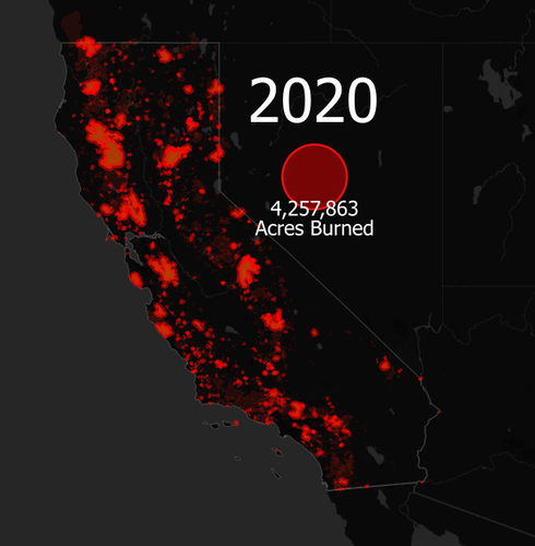
The wildfire polygons are set to display the current year selected by the temporal controller panel. When exporting, a very transparent layer of the past wildfires remains, to show the previously burned areas. These show just a few of the cool features available in the temporal analysis features in QGIS.
The project also uses some other nifty QGIS tricks, including a geometry generator point symbolizing the total burned area for that year, and dynamic text labels showing the area attribute. The current year text is also dynamic text, using the function: year( @map_end_time).
To keep the project size small, the polygons are simplified. So the fire areas will look quite chunky when zoomed in, but look great at a statewide scale.
In the end, the results can be exported and converted into a GIF using a free tool like ezgif.com. See the link below for an example of a GIF product showing this time series: https://drive.google.com/file/d/1S8JKE1CPfgr9GJfEaR-p4je32BFxXdyM/view
The data is from CalFire, who provides high quality fire perimeter data dating back into the 1800's! I only included the past ~25 years here to save space, but the same project can be applied to a longer time series.
Have some ideas on how to make this project better? Please comment below ⬇️⬇️⬇️
Thank you very much! Those of us who don't use Windows don't have a Tahoma font license and must use a replacement or purchase it. The project would be more inclusive and would display the same on all machines if you use free fonts. But the temporal configuration is very interesting and the project is welcome. Thank you!
Reviewed by gabrieldeluca 10 months ago

This GeoPackage is made available under the CC-0 license.

Flagship membership

Flagship membership

Large membership

Large membership

Large membership

Large membership

Large membership

Large membership

Large membership

Large membership

Large membership

Large membership


