This Map is made available under the CC-0 license.
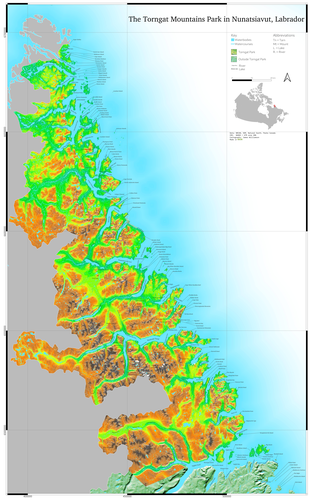
I created this map to explore how toponyms and Tanaka contours could be used to create a map showing the landscape of northern Labrador, and the Torngat Park, in Nunatsiavut.
The vector itself, the illuminated Tanaka, was created from singlepart lines using a query in QGIS. The raster was prepared from the NRCAN Medium Resolution DEM, and the toponyms were taken from the NRCAN toponym database.
This map was printed at 5x3 ft. For the original, more detailed version, contact me at jwilliamsongis@gmail.com and for more maps and graphics, https://bsky.app/profile/northernmaps.bsky.social
Thank you!
Reviewed by gabrieldeluca 10 hours ago

This Map is made available under the CC-0 license.

Flagship membership

Flagship membership

Flagship membership

Large membership

Large membership

Large membership

Large membership

Large membership

Large membership

Large membership

Large membership

Large membership