
This Map is made available under the CC-0 license.
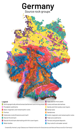
Rock type map created using QGIS and Blender Software, Data sources from Federal Institute for Geosciences and Natural Resources (Living Atlas) and Esri Germany.
Hi Lungo - that is beautiful! Do you think you could mention the map being made by QGIS and Blender on the map - I am worried that someone looking at it out of context will think it is made using Esri since that is the only product mentioned on the map. Also some fixes for your description: Rock type map created on QGIS and Blender Software, Data sourced from Federal Institute for Geosciences, Germany, Natural Resources (Living Atlas) and Esri Germany.
Reviewed by timlinux 1 year ago
Thank you
Reviewed by timlinux 1 year ago

This Map is made available under the CC-0 license.

Flagship membership

Flagship membership

Large membership

Large membership

Large membership

Large membership

Large membership

Large membership

Large membership

Large membership

Large membership

Large membership


