
This Map is made available under the CC-0 license.
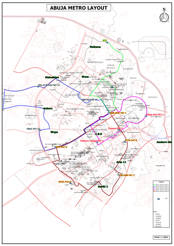
Abuja Metro Layout Map Creation Using QGIS I produced a detailed metro layout map of Abuja using QGIS software, leveraging OpenStreetMap (OSM) data for accuracy. The process involved: ✅ Extracting Key Features – Using the Download OSM Data by Rectangle Selection plugin, I obtained roads, buildings, and Points of Interest (POIs) from OpenStreetMap. ✅ Defining Coverage – I clipped the dataset to focus on the relevant analysis area. ✅ Incorporating Metro Points & Routes – Based on client-provided information, I mapped FAT metro points and aligned them to define metro routes, joining them into structured ring lines. ✅ Adding District Labels – I enriched the map with district names as per the client’s specifications. ✅ Finalizing the Metro Map – Using the Print Composer, I carefully arranged all layers to create a clear, professional, and visually appealing metro map. The result? A well-structured, data-driven metro layout ready for use in urban planning and transportation analysis!
Hi, Thank you for your submission!
Reviewed by gabrieldeluca 1 year ago

This Map is made available under the CC-0 license.

Flagship membership

Flagship membership

Large membership

Large membership

Large membership

Large membership

Large membership

Large membership

Large membership

Large membership

Large membership

Large membership


