
Creator:
Uploaded:
Downloads:
Description:
Map Tags
QGIS Map Gallery is a collection of maps created with QGIS. They are a great way to learn how to use QGIS and to get inspiration for your own maps.
1 record found.
by Lockhart, 15 March 2025
Updated on 16 March 2025
| Name | Creator | Upload Date | |||
|---|---|---|---|---|---|

|
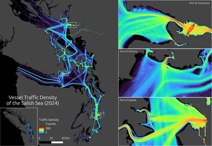
Vessel Traffic Density of the Salish Sea (2024) | 1,001 | Lockhart | 15 Mar. 2025 |
Creator:
Uploaded:
Downloads:
Description:

Flagship membership

Flagship membership

Large membership

Large membership

Large membership

Large membership

Large membership

Large membership

Large membership

Large membership

Large membership

Large membership


