This Processing Script is made available under the CC-0 license.
Raster rescale functions
# -*- coding: utf-8 -*-
"""
QGIS Processing Toolbox script for rescaling rasters using inflection points.
Based on r.fuzzy.set from GRASS GIS:
https://grass.osgeo.org/grass-stable/manuals/addons/r.fuzzy.set.html
Author: Paulo van Breugel
"""
from qgis.core import (
QgsProcessingAlgorithm,
QgsProcessingParameterRasterLayer,
QgsProcessingParameterString,
QgsProcessingParameterNumber,
QgsProcessingParameterEnum,
QgsProcessingParameterRasterDestination,
QgsProcessingException,
)
from qgis.PyQt.QtCore import QCoreApplication
import numpy as np
from osgeo import gdal
def tr(text):
return QCoreApplication.translate("FuzzyRescale", text)
class FuzzyRescale(QgsProcessingAlgorithm):
INPUT = "INPUT"
LEFT = "LEFT"
RIGHT = "RIGHT"
SHAPE = "SHAPE"
FUNCTION = "FUNCTION"
OUTPUT = "OUTPUT"
def initAlgorithm(self, config=None):
self.addParameter(
QgsProcessingParameterRasterLayer(self.INPUT, tr("Input Raster Layer"))
)
self.addParameter(
QgsProcessingParameterString(
self.LEFT,
tr("Left side (A,B)"),
defaultValue="",
optional=True,
)
)
self.parameterDefinition(self.LEFT).setHelp(
tr(
"Optional. Enter two comma-separated values A,B to define the left slope of the rescale function."
)
)
self.addParameter(
QgsProcessingParameterString(
self.RIGHT, tr("Right side (C,D)"), optional=True
)
)
self.parameterDefinition(self.RIGHT).setHelp(
tr(
"Optional. Enter two comma-separated values C,D to define the right slope of the rescale function."
)
)
self.addParameter(
QgsProcessingParameterNumber(
self.SHAPE,
tr("Shape Parameter (-1 to 1)"),
QgsProcessingParameterNumber.Double,
0.0,
False,
-1.0,
1.0,
)
)
self.parameterDefinition(self.SHAPE).setHelp(
tr(
"Controls the sharpness of the curve.\n"
"-1 = soft transition\n"
" 0 = default\n"
"+1 = sharp transition"
)
)
self.addParameter(
QgsProcessingParameterEnum(
self.FUNCTION,
tr("Rescale function"),
options=["Linear", "S-shaped", "G-shaped", "J-shaped"],
defaultValue=0,
)
)
self.parameterDefinition(self.FUNCTION).setHelp(
tr(
"Choose the type of rescale function to apply:\n"
"- Linear: piecewise linear slope(s)\n"
"- S-shaped: smooth curve with sinusoidal shape\n"
"- G-shaped: gradual increase\n"
"- J-shaped: steep increase"
)
)
self.addParameter(
QgsProcessingParameterRasterDestination(
self.OUTPUT, tr("Output Rescaled Raster")
)
)
def processAlgorithm(self, parameters, context, feedback):
shape = self.parameterAsDouble(parameters, self.SHAPE, context)
func_index = self.parameterAsEnum(parameters, self.FUNCTION, context)
function_name = ["Linear", "S-shaped", "G-shaped", "J-shaped"][func_index]
left_str = self.parameterAsString(parameters, self.LEFT, context)
right_str = self.parameterAsString(parameters, self.RIGHT, context)
def parse_pair(pair_str):
try:
values = [float(v.strip()) for v in pair_str.split(",")]
if len(values) != 2:
raise ValueError
return values
except Exception:
raise QgsProcessingException(
f"Invalid format for value pair: '{pair_str}'. Use format: value1,value2"
)
a, b = parse_pair(left_str) if left_str else (None, None)
c, d = parse_pair(right_str) if right_str else (None, None)
use_left = a is not None and b is not None
use_right = c is not None and d is not None
if not (use_left or use_right):
raise QgsProcessingException(
"Please provide at least one valid inflection point pair (left or right)."
)
mode = "both" if use_left and use_right else "left" if use_left else "right"
input_layer = self.parameterAsRasterLayer(parameters, self.INPUT, context)
output_path = self.parameterAsOutputLayer(parameters, self.OUTPUT, context)
dataset = gdal.Open(input_layer.source(), gdal.GA_ReadOnly)
band = dataset.GetRasterBand(1)
arr = band.ReadAsArray().astype(np.float32)
def normalize(val):
return np.clip(val, 0, 1)
def rescale_linear(x):
result = np.zeros_like(x)
if use_left:
result[(x > a) & (x < b)] = (x[(x > a) & (x < b)] - a) / (b - a)
if not use_right:
result[(x >= b)] = 1.0
if use_right:
result[(x > c) & (x < d)] = (d - x[(x > c) & (x < d)]) / (d - c)
if use_left and b is not None and c is not None:
result[(x >= b) & (x <= c)] = 1.0
elif not use_left:
result[(x <= c)] = 1.0
return normalize(result)
def rescale_s(x):
m = 2 ** np.exp(2 * abs(shape)) if shape != 0 else 2
linear_result = rescale_linear(x)
output = np.ones_like(linear_result)
mask = linear_result < 1.0
if shape > 0:
output[mask] = np.sin(linear_result[mask] * np.pi / 2) ** m
elif shape < 0:
x_clip = np.clip(linear_result[mask], 0, 1)
cos_part = np.cos(x_clip * np.pi / 2)
cos_part = np.where(cos_part < 1e-8, 0.0, cos_part)
output[mask] = 1 - (cos_part**m)
else:
output[mask] = np.sin(linear_result[mask] * np.pi / 2) ** 2
return normalize(output)
def rescale_g(x):
m = 2 ** np.exp(-2 * shape) if shape < 0 else 2 ** (1 - shape)
linear_result = rescale_linear(x)
output = np.ones_like(linear_result)
mask = linear_result < 1.0
safe_val = np.clip(linear_result[mask], 1e-6, 1)
output[mask] = np.tan(safe_val * np.pi / 4) ** (1 / m)
return normalize(output)
def rescale_j(x):
m = 2 ** np.exp(2 * shape) if shape > 0 else 2 ** (1 + shape)
linear_result = rescale_linear(x)
output = np.ones_like(linear_result)
mask = linear_result < 1.0
safe_val = np.clip(linear_result[mask], 1e-6, 1)
output[mask] = np.tan(safe_val * np.pi / 4) ** m
return normalize(output)
if function_name == "Linear":
out_arr = rescale_linear(arr)
elif function_name == "S-shaped":
out_arr = rescale_s(arr)
elif function_name == "G-shaped":
out_arr = rescale_g(arr)
elif function_name == "J-shaped":
out_arr = rescale_j(arr)
else:
raise QgsProcessingException(f"Function '{function_name}' not implemented.")
driver = gdal.GetDriverByName("GTiff")
out_ds = driver.Create(
output_path, arr.shape[1], arr.shape[0], 1, gdal.GDT_Float32
)
out_ds.SetGeoTransform(dataset.GetGeoTransform())
out_ds.SetProjection(dataset.GetProjection())
out_ds.GetRasterBand(1).WriteArray(out_arr)
out_ds.GetRasterBand(1).SetNoDataValue(np.nan)
out_ds.FlushCache()
return {self.OUTPUT: output_path}
def name(self):
return "rescale_rescale_inflection"
def displayName(self):
return tr("Rescale or fuzzy membership functions")
def group(self):
return tr("Raster analysis")
def groupId(self):
return "raster_analysis"
def shortHelpString(self):
return tr(
"<h2>Description</h2>"
"<p>In addition to the built-in Fuzzify function available in the QGIS toolbox, this custom rescale tool offers "
"an extended set of rescale functions that you can use to transform your raster data and are arguably easier to use.</p>"
"<h2>Shape</h2>"
"<p>To determine how values of the input raster are transformed, four different functions are available "
"(linear, S-shaped, G-shaped and J-shaped). Each function defines how values are transformed between 0 and 1. "
"Choose the one that best reflects how suitability increases or decreases across your landscape. The functions can "
"be applied to the left boundary (suitability increasing with input values) or the right boundary (suitability "
"decreasing with input values).</p>"
"<p>With the <b>shape parameter</b> (-1 to 1), you can fine-tune how gradual or abrupt the shift from unsuitable "
"to suitable (or vice versa) should be. The default is 0. Positive values result in a steeper transition, while "
"negative values result in a gentler transition.</p>"
"<h2>Boundary</h2>"
"<p>You can define either 2 or 4 inflection points, depending on whether you want to rescale just one side "
"(lower or higher end of the distribution) or both sides of the distribution. Use the <b>Left side</b> parameter "
"to enter two comma-separated values A,B and the <b>Right side</b> parameter to enter two comma-separated values C,D.</p>"
"<p><b>Both A,B and C,D provided</b> (two-sided rescaling): values < A or > D become 0; values between B and C "
"become 1; values between A and B or between C and D are rescaled between 0 and 1 using the selected function.</p>"
"<p><b>Only A,B provided</b> (left-sided rescaling): values < A become 0; values > B become 1; values between "
"A and B are rescaled using the selected function.</p>"
"<p><b>Only C,D provided</b> (right-sided rescaling): values < C become 1; values > D become 0; values between "
"C and D are rescaled using the selected function.</p>"
"<p>The points do not have to be in map range, but this may lead to only 0 or 1 membership for the whole map.</p>"
"<h2>Note</h2>"
"<p>Based on the <em>r.fuzzy.set</em> addon for GRASS. See its "
"<a href='https://grass.osgeo.org/grass-stable/manuals/addons/r.fuzzy.set.html'>manual page</a> for more information about the "
"functions and a visual explanation of the parameters.</p>"
"<p>The term 'rescale function' is used instead of 'fuzzy membership function' because it can be used in applications "
"other than fuzzy logic, in contexts such as raster normalization and suitability mapping.</p>"
"<h2>References</h2>"
"<p>Jasiewicz, J. (2011). A new GRASS GIS fuzzy inference system for massive data analysis. Computers & Geosciences "
"(37) 1525-1531. DOI https://doi.org/10.1016/j.cageo.2010.09.008</p>"
"<p>r.fuzzy.set addon for GRASS <a href='https://grass.osgeo.org/grass-stable/manuals/addons/r.fuzzy.set.html'>manual page</a></p>"
"<h2>Author</h2>"
"<p><a href='https:ecodiv.earth'>Paulo van Breugel</a>, <a href='https://has.nl'>HAS green academy</a>, "
"<a href='https://www.has.nl/en/research/professorships/innovative-bio-monitoring-professorship/'>Innovative Biomonitoring research group</a>, "
"<a href='https://www.has.nl/en/research/professorships/climate-robust-landscapes-professorship/'>Climate-robust Landscapes research group</a></p>"
)
@staticmethod
def createInstance():
return FuzzyRescale()
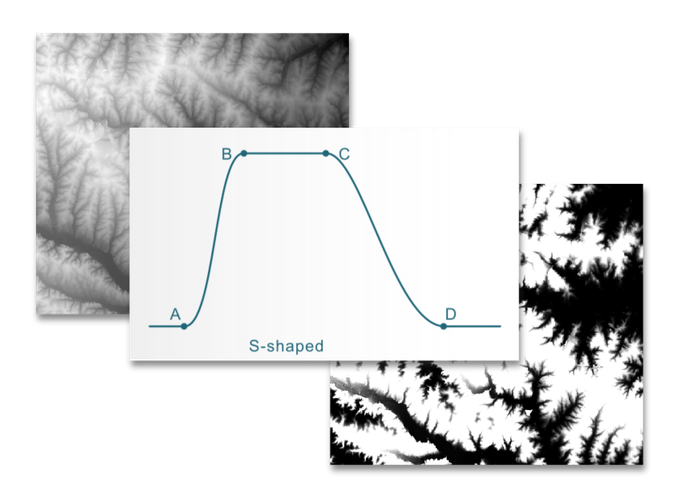
Rescale tool that offers a flexible way to rescale your raster data. Or, use it to calculate the membership value of any raster map according to a user's rules. Based on the r.fuzzy.set module for GRASS. For more information, see the manual page
Great! Thank you!
Reviewed by gabrieldeluca 2 months, 4 weeks ago

This Processing Script is made available under the CC-0 license.

Flagship membership

Flagship membership

Flagship membership

Large membership

Large membership

Large membership

Large membership

Large membership

Large membership

Large membership

Large membership

Large membership